The Airborne eXpendable Buoy Processing System (AXBPS) profile editing package is meant to enable users to quality control AXBT temperature-depth profiles, AXCTD temperature- and salinity-depth profiles, and AXCP temperature- and current-depth profiles, guided by an automated quality control algorithm and further aided by climatology and bathymetry data for the region of interest to reduce the background oceanographic knowledge necessary on the part of the user.
Layout
The profile editor interface is divided into three sections:- Interactive profile temperature-depth (and salinity-depth for AXCTDs or current-depth for AXCPs) plot (left)
- Static profile location and bathymetry plot (bottom right)
- Profile editing tools (top right)
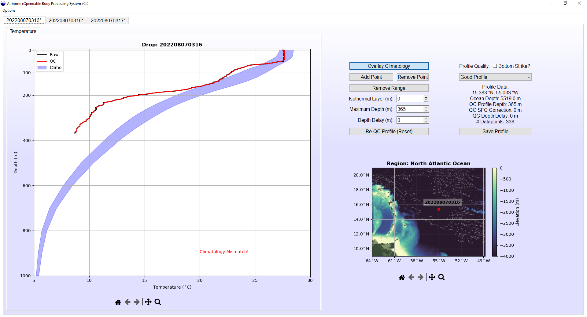
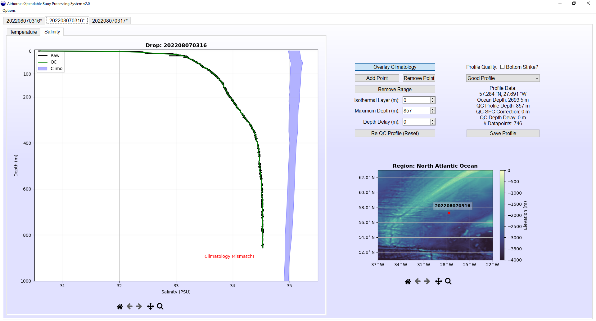
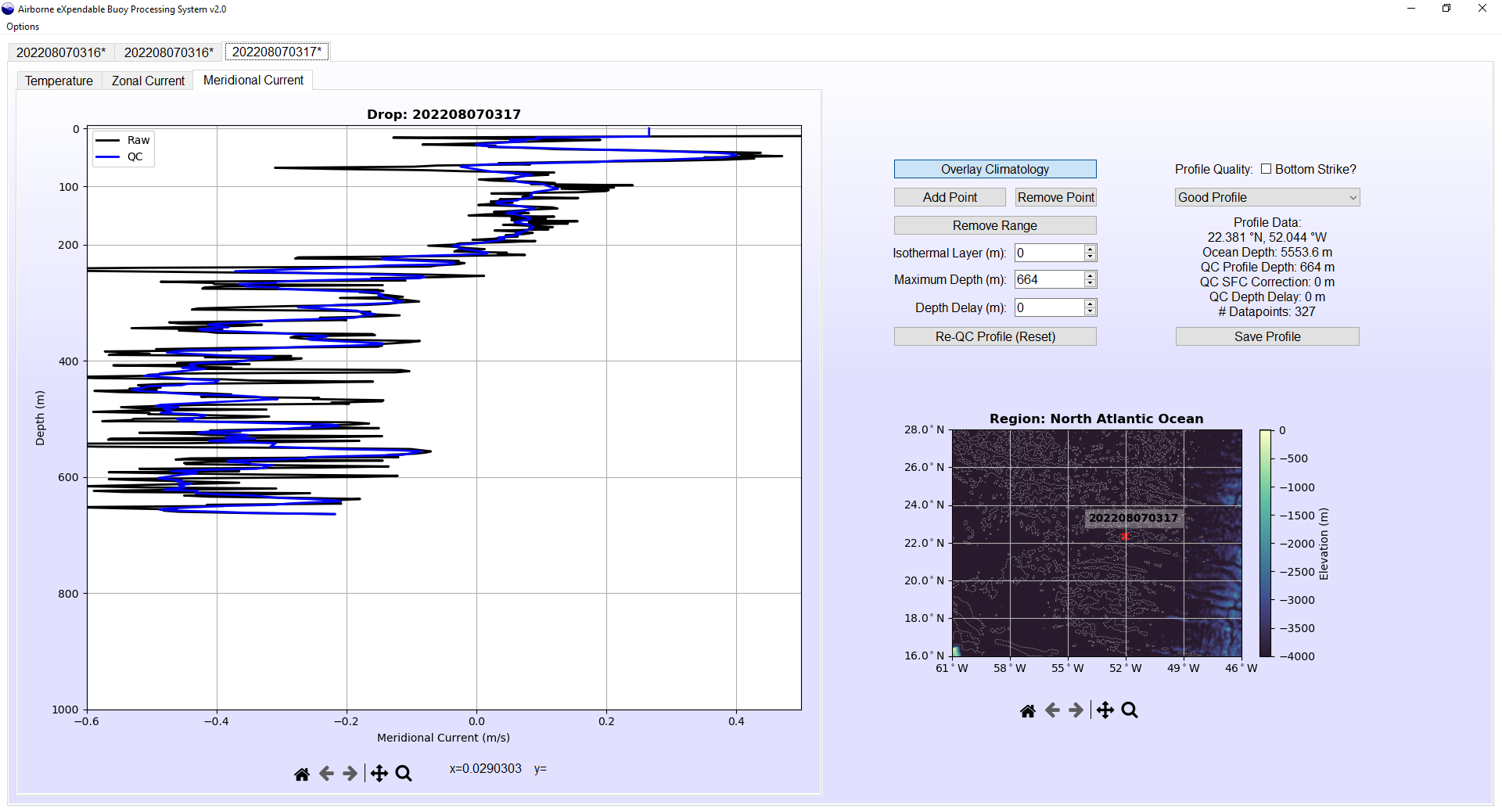
The top right section of the profile editor interface includes the tools necessary to manipulate and edit the temperature, salinity, and/or current profiles. Along the top of the plot is a toolbar that includes controls to pan and zoom around the temperature-depth plot in order to inspect and edit the profile in greater detail. It is worth noting that the controls in this toolbar do not edit the profile, and only change the user's view (for example, the back and forward arrows do not undo and redo edits to the profile, rather they allow the user to move back and forward to the previous and next views of the profile, respectively). The remaining interactive widgets are organized into two columns. The "Overlay Climatology" button in the left column allows the user to toggle the visibility of the blue climatology shading. All other buttons and spinboxes in the left column allow the user to edit the quality-controlled profile(s). When editing AXCTD temperature and salinity or AXCP temperature and current profiles, the buttons to add or remove profile points will only be applied to the currently selected profile (temperature, salinity, or current) but changes to the maximum depth, etc. will be applied to both or all three profiles. The right column includes profile information. The text box includes data such as exact position, ocean depth at that position, and the number of datapoints in the quality-controlled profile. The dropdown menu provides a list of common profile discrepancies that can be used to flag a profile with uncorrectable features (such as an isothermal profile due to a probe that failed to deploy properly). The "Bottom Strike" checkbox is used to note if it appears that the probe reached the ocean floor (e.g. due to erroneous warning or a profile whose maximum depth exceeds the indicated ocean depth at its position), as this information is incorporated in the output JJVV file.
Opening a Profile Editor Tab
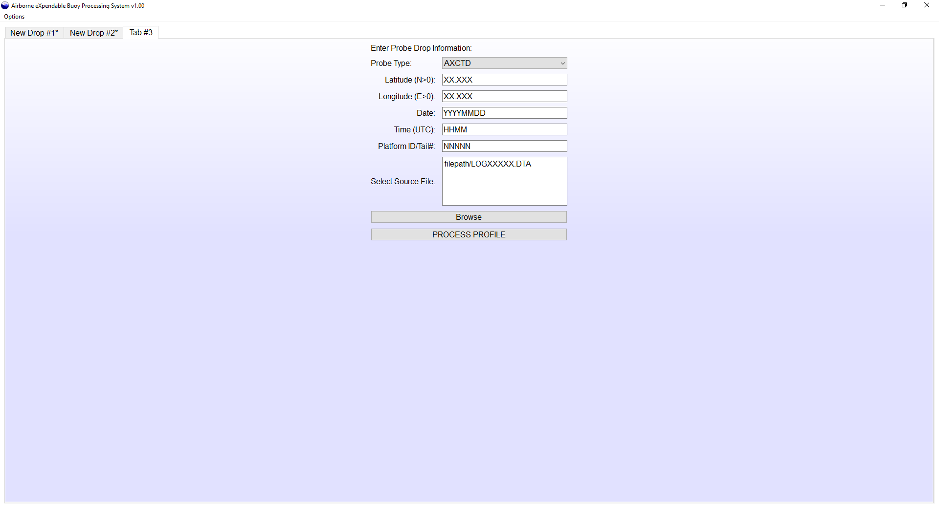
Raw profiles can be loaded into a profile editor interface by one of two means:- Loaded directly from the AXBPS Data Acquisition System interface by selecting "Process Profile" after acquiring data in realtime or reprocessing from an audio file
- Read from an ASCII file format using the AXBPS ASCII file selection interface
Editing Components
Users can make four categories of edits to the quality-controlled profile (listed in order of appearance on the GUI, from top to bottom):- Add or remove individual points or a range of points
- Specify a surface isothermal region to remove erroneous surface spikes
- Truncate the base of the profile to correct for bottom strikes or excessive interference
- Vertically shift the profile to correct for VHF interference
Individually removing points or spikes may be necessary when the autoQC algorithm's spike removal feature fails to identify all erroneous datapoints. This is especially common when there is extreme variability due to VHF interference that saturates the standard deviation filter and increases the deviation necessary to identify a datapoint as erroneous. Additionally, if too many points are truncated and important profile characteristics are missed, adding individual points may be necessary. Individual points can be added and ranges of points can be added or removed with a point selection tool integrated into the AXBPS Profile Editor interface.
Occasionally, surface observations (particularly temperature) include erroneous spikes due to probe acclimation or interference. The AXBPS Profile Editor provides an option to manually create an isothermal layer at the surface by setting the temperature, salinity, and/or currents of all datapoints above a specified depth equal to the observed value at that depth. For example, if an AXBT's surface temperature erroneously starts at 26°C at the surface, but warms to a realistic value of 28°C at 5 m, setting the isothermal layer value to 5 m will change the temperatures of all datapoints above 5 m to 28°C, removing the surface spike. However, care must be taken by the operator to distinguish diurnal surface heating and cooling effects from erroneous features.
In some cases, it is necessary to truncate base of the profile, either to remove data from a bottom strike or to remove excessively variable (strong-interference) data. Finally, excessive VHF interference (either noise or an unexpected signal) that falsely triggers the start of profile collection can be overlooked by the autoQC algorithm if the gap between interference and valid data is less than 5 m or the interference extends without gaps beyond 50 m. If the correct profile surface is easily identifiable, the entire profile can be shifted upward manually. This interference should only affect AXBT profiles and applying the depth delay correction is not recommended for AXCTD or AXCP profiles. User-specified surface isothermal layer generation and profile truncation are not applied until after the vertical shift, so applying a vertical shift of 200 m and profile truncation at 400 m would first shift the profile upwards by 200 m, and then truncate all data that were below 600 m on the raw profile).
Quality Control Flags
In addition to profile edits, users can apply quality control flags to note any profile discrepancies. First, a checkbox allows users to note whether the profile was a bottom strike. This information is encoded in the JJVV (temperature only) output file format. Additionally, a dropdown menu allows users to select one of ten quality control (QC) codes depending on the state of the quality-controlled profile. QC code 1 (Good Data) should be used for a profile that has been successfully quality-controlled (whether edits were necessary or not) and is of sufficient quality to assimilate in models or use for other means. QC code 0 (No QC) should be used when, due to time or other operational constraints, no quality control was conducted on the profile. QC code 8 (Action Required) should be used when the profile was reviewed but additional steps (e.g. point removal) are necessary before the profile is accurate. The remaining QC codes describe common issues with air-launched probes. Only profiles with QC codes 1, 3, and 9 (case-dependent for the latter two codes) should be used for other applications.| Code | Name | Description |
|---|---|---|
| 0 | No QC | No quality control was conducted |
| 1 | Good data | Any profile discrepancies were corrected |
| 2 | No Signal | No signal was received from the probe |
| 3 | Spotty/Interference | Probe signal received but either missing sections or degraded by excessive interference |
| 4 | Bad data | Signal received but was bad quality for a reason uncovered by other QC codes |
| 5 | Isothermal | Temperature profile was unexpectedly isothermal |
| 6 | Late Start or Hung Probe | Probe either did not start transmitting on time or probe failed to immediately detach from surface float |
| 7 | Slow Falling | Probe sank slowly through the water column, resulting in inaccurate depths |
| 8 | Action Required | Profile was reviewed but requires additional corrections |
| 9 | Suspect Climo/Neighbor Mismatch | Profile either does not match climatology or is exceedingly different from other nearby profiles |
Output File Formats
In addition to loading data processed either in realtime or from a WAV file using the signal processor interface, AXBPS supports loading data from LOG, EDF, DAT, and NVO ASCII files. It is also possible to read in profiles from JJVV and FIN files (described in the next paragraph), but it is not recommended as these file formats typically contain lower resolution data that has generally already undergone some form of post-processing.AXBPS supports exporting profile data to four ASCII file formats (FIN, DAT, EDF, and JJVV), one binary format (WMO BUFR), and both profile and location/bathymetry plots. FIN files contain drop metadata and quality-controlled profiles subsampled and interpolated to a 1m resolution. These files are formatted identically to NVO files, the only exception being that NVO files include all raw profile information whereas FIN files only include quality-controlled, 1m resolution data.
JJVV files include only the subsampled points from a quality-controlled AXBT profile (these typically include only inflection points and critical levels in order to reduce file size). Like FIN/NVO files, JJVV files include a header with drop metadata, but in JJVV files each profile datapoint is encoded as five digits: the first two represent the depth in meters, and the last three represent the temperature to the tenths of a degree Celsius (for example, an observation of 28.3°C at 54 meters would be encoded as '54283'). Temperature-depth observations are listed with increasing depth, and every time depth increases into the next hundreds place, this is denoted by another five digit code: '999', followed by the new hundreds of meters (for example, once depth exceeds 100m, '99901' would be appended to the file, and a subsequent listing of '54283' would now indicate a measurement of 28.3°C at 154m). An example of the JJVV file format is also provided above.
BUFR files are binary files that follow a format outlined by the World Meteorological Organization (WMO) using a large series of tables to specify a common method of encoding large amounts of data from a wide range of sources (e.g. satellites, radiosondes, oceanographic observations) while minimizing file size. BUFR files are divided into six sections, labelled zero through five. Sections 0,1, and 5 contain primarily static data to confirm that the file is formatted correctly, and some basic information such as date and time. Section 2 is optional, used to encode any necessary information without a proper entry in the WMO BUFR tables (this section is unused in AXBPS-generated BUFR files). Section 3 contains F-X-Y descriptors, used to identify the type of data being transmitted (which is encoded in Section 4). AXBT BUFR files encode date and time, latitude and longitude to the hundredth of a degree, and temperature and depth to the tenths place in Kelvin and meters, respectively. Currently AXBPS only supports saving temperature-depth BUFR files; BUFR files can be generated for AXCTDs and AXCPs but the resulting files will exclude the salinity and current data, respectively. A guide to the BUFR version used by AXBPS (WMO FM94 BUFR Edition 4) is available at https://community.wmo.int/activity-areas/wmo-codes/manual-codes/latest-version.
Settings
The AXBPS profile editor settings are divided into four sections: climatology options, file save formats, autoQC thresholds, and additional settings. Climatology settings are listed in the top right corner of the settings window. When checked, the "Use climatology to detect bottom strikes" option compares the slope of the quality-controlled profile to the slope of the climatological profile to identify erroneous isothermal or warming features or salinity changes caused by a bottom strike and automatically truncate the profile. When "Autocompare profile to climatology" is checked, a red "Climatology Mismatch" will appear if less than 50% of the points in the quality-controlled profile are within the blue-shaded climatology region. "Overlay climatology in saved plots" controls whether the blue climatology shading is included in the output profile plots. The option to "ID bottom strikes with NOAA bathymetry" compares the profile depth to estimated ocean depth at the drop's position from the NOAA ETOPO1 global relief dataset and automatically truncates the profile if it exceeds that depth. Finally, "ID AXBT false starts" identifies instances where erroneous VHF interference is falsely interpreted as the start of AXBT profile transmission. When selected, this automated check is only applied to AXBT profiles.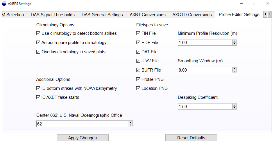
The "Filetypes to Save" column lists seven different output file formats: four ASCII formats (FIN, EDF, DAT, and JJVV), one binary format (BUFR) and two images (profile and location plots identical to those in the Profile Editor interface). The two checkboxes in the bottom left corner of the window control automatic corrections applied by the autoQC algorithm. The "ID bottom strikes with NOAA ETOPO1 bathymetry data" checkbox determines if bathymetry data is used to automatically truncate profiles whose maximum depths are greater than the ETOPO1-indicated ocean depth at the profile location, and the "ID false starts due to VHF interference" checkbox controls whether gaps in data in the upper ocean are identified as signs of VHF interference causing false starts and used to vertically shift the profile. Finally, the spinbox in the bottom left is used to identify the center through which data is uploaded to the Global Telecommunications System (GTS), if applicable. This identification is a necessary field for the WMO-formatted BUFR message.
The rightmost column of settings includes three spinboxes that control thresholds used by the autoQC algorithm. The minimum profile resolution is the resolution (in meters) at which points are downsampled following smoothing and despiking. The smoothing window is the length (in meters) of the running smooth filter used to remove high frequency variability before downsampling. Finally, the despiking coefficient adjusts how sensitive the autoQC algorithm is for removing spikes (a higher coefficient results in the inclusion of more data and a lower coefficient results in the exclusion of more data). The mathematical definition of this coefficient and its role in the autoQC algorithm are more clearly defined in the user manual.